Business Impact
Mission-Critical Performance
Deliver better outcomes for citizens with intelligent geospatial solutions designed for government operations.
Rapid Response
Faster emergency response times through intelligent routing, resource optimization, and real-time coordination.
Enhanced Security
Improved threat detection and prevention with advanced geospatial intelligence and predictive analytics.
Better Service
Enhanced citizen services through optimized resource allocation and data-driven decision making.
Cost Efficiency
Reduced operational costs through automated workflows, optimized routing, and resource management.
Our Solutions
Comprehensive Government Solutions
Secure geospatial intelligence solutions for public safety, emergency management, and defense operations.
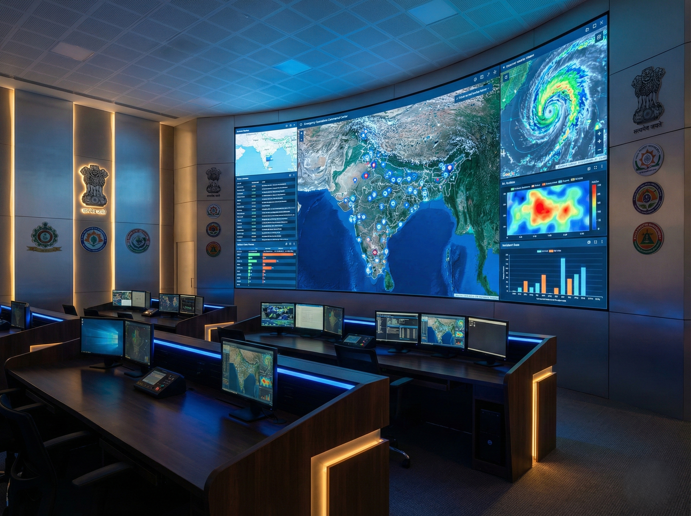
Emergency Management
Coordinate rapid response with real-time situational awareness, resource allocation, and incident management for natural disasters and emergencies.
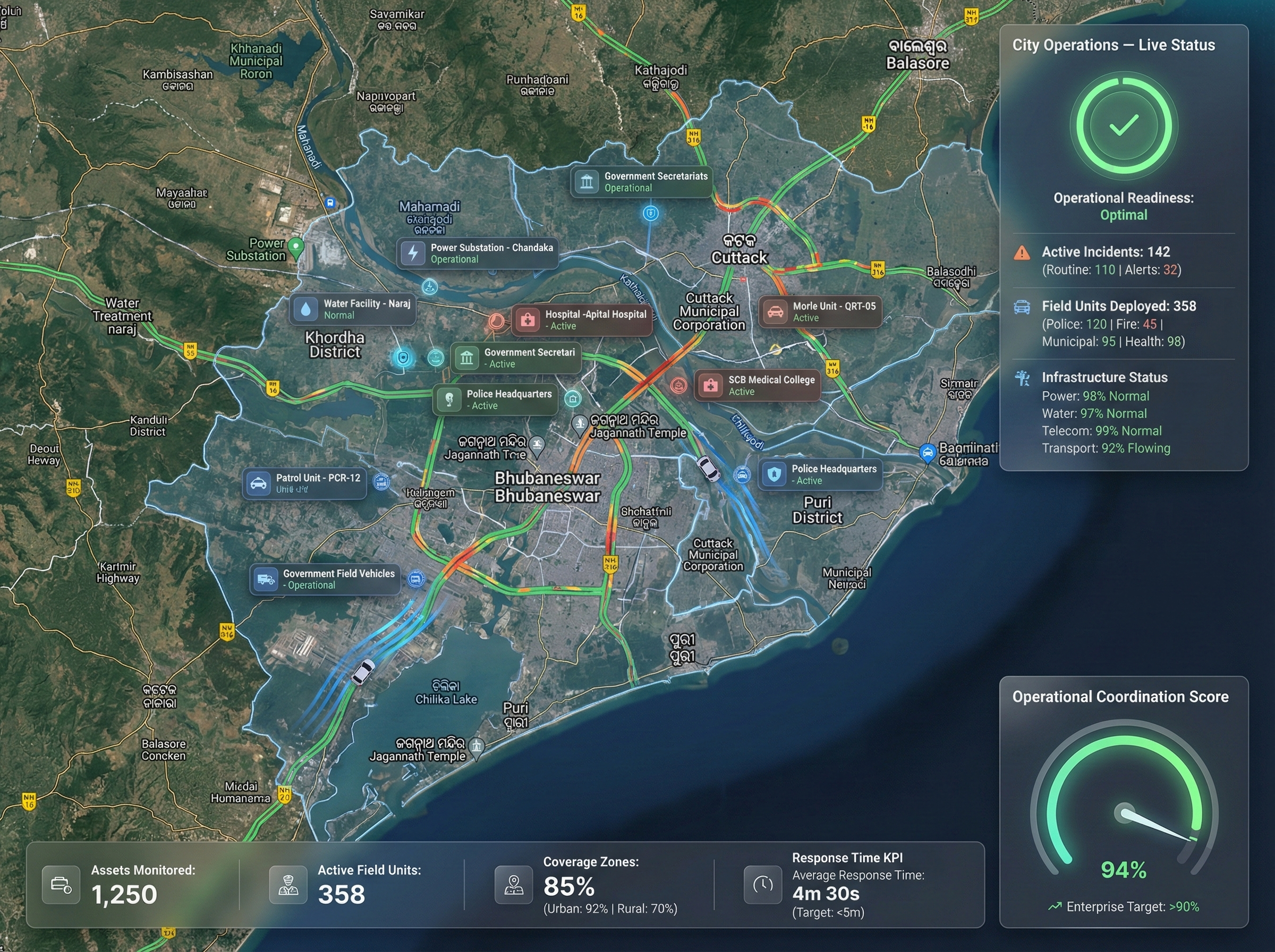
Public Safety Operations
Enhance law enforcement and first responder capabilities with location intelligence for crime prevention, patrol optimization, and incident response.
Public Health Management
Track disease outbreaks, manage vaccination programs, and optimize healthcare resource distribution with geospatial analytics.
Border & Perimeter Security
Monitor critical infrastructure and borders with advanced surveillance, threat detection, and strategic defense planning capabilities.
Asset & Facility Management
Comprehensive tracking and management of government assets, facilities, and equipment with real-time location visibility.
Smart City Infrastructure
Build connected urban environments with intelligent infrastructure planning, traffic management, and public service optimization.
Real-World Applications
Proven Solutions for Complex Challenges
See how agencies worldwide leverage our platform to solve their most demanding operational challenges.
Disaster Response & Recovery
Coordinate multi-agency response efforts, track resources, and manage evacuation routes during natural disasters and emergencies.
Crime Mapping & Analysis
Identify crime hotspots, predict patterns, and optimize patrol routes to enhance community safety and law enforcement effectiveness.
Critical Infrastructure Protection
Monitor and secure vital assets including power grids, water systems, and communication networks against threats and vulnerabilities.
Pandemic & Health Crisis Management
Track disease spread, manage testing and vaccination sites, and coordinate healthcare resource distribution during public health emergencies.
Platform Capabilities
Complete Emergency Operations Capabilities
Everything you need to manage public safety, emergency response, and critical operations with confidence.
Integrations
Seamless System Integration
Connect with existing emergency management, CAD, and RMS systems out of the box.
CAD Systems
Computer-Aided Dispatch integration
RMS Integration
Records Management System connectivity
GIS Platforms
ArcGIS, QGIS, and other GIS tooling
Get Started
Ready to Enhance Public Safety Operations?
Discover how our secure geospatial intelligence solutions can transform your emergency response and public safety operations.